Description – Crossing of Vercors mountains – Standard range
C055-STANDARD Crossing of Vercors mountains A stronghold steeped in history, enclosed by the Isere, the Drôme and the Arc rivers, the massive silhouette of the Vercors stands impressively in its landscape. A large limestone plateau, carved out by rivers and worn down by erosion, it offers a variety of exceptional beauty spots: vertical cliffs, […]
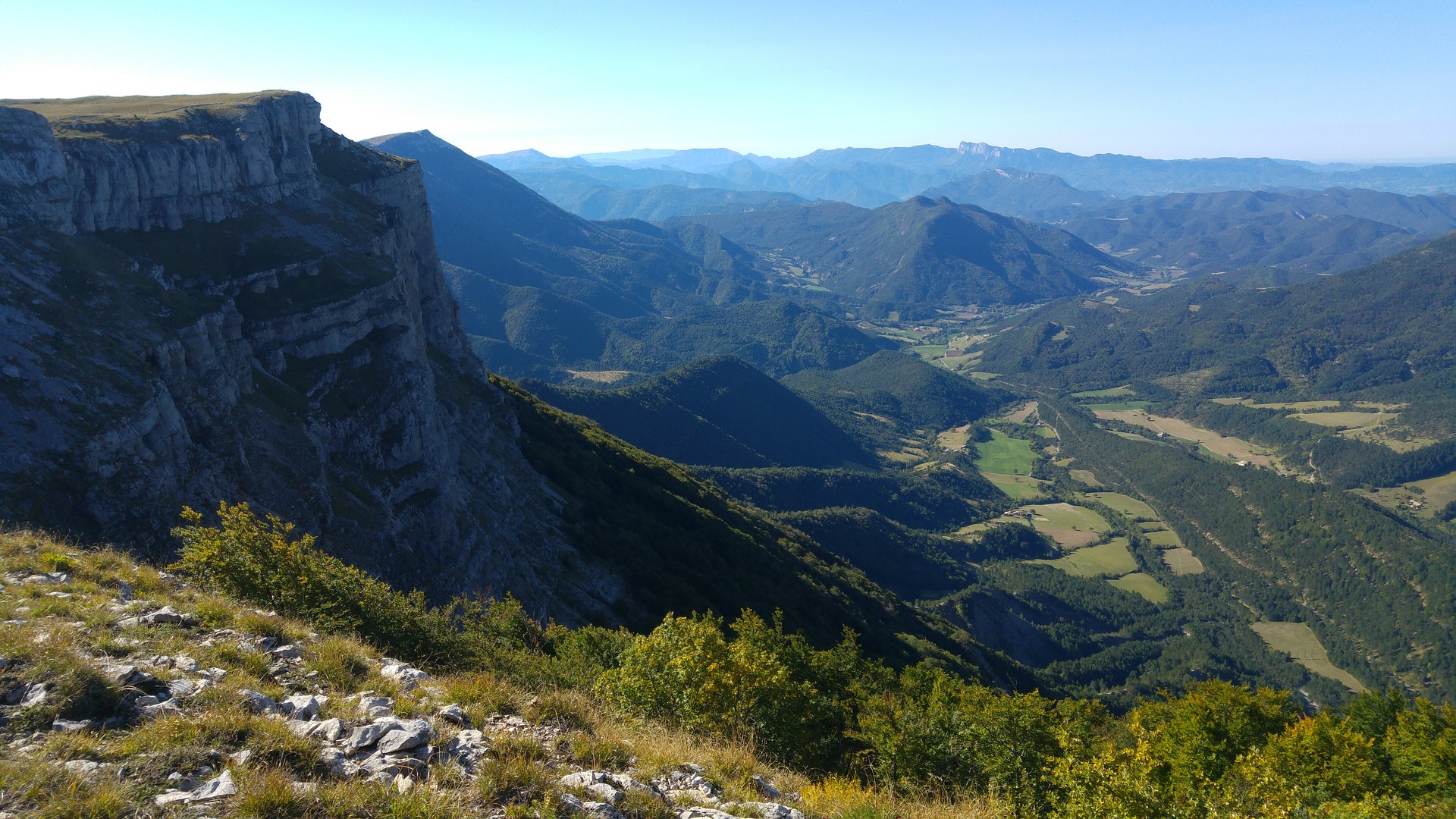
C055-STANDARD Crossing of Vercors mountains
A stronghold steeped in history, enclosed by the Isere, the Drôme and the Arc rivers, the massive silhouette of the Vercors stands impressively in its landscape. A large limestone plateau, carved out by rivers and worn down by erosion, it offers a variety of exceptional beauty spots: vertical cliffs, deep and narrow gorges, imposing creeks, barren areas and wide, lush valleys. More than half of the Vercors is covered by forest which shelters an impressive selection of flora and fauna. Full of contrasts, the Vercors stretches more than 40 km north to south between the alpine valleys of the Montagnes de Lans, the barren “Haut Plateaux” dominated by the Mont Veymont, and the first vineyards and gentle Mediterranean climate of Diois.
Itinerary
Day 1 – Arrival at AUTRANS. Situated at a height of more than 1000 meters, the city of Autrans offers a landscape that is very typical of Vercors : open, undulating spaces, numerous grazing lands surrounded by forests of spruce and beech trees, and scattered hamlets. You will spend the night in a hotel with a warm reception and a swimming pool. Dinner, lodging and breakfast in a three-star hotel with swimming pool.
Day 2 – AUTRANS – RENCUREL (5 and a half hour walk –alt. gain: 450 meters). You will leave Autrans after having admired the lovely Romanesque church tower and direct yourself towards La Ferme de Blanc-Brude (farm). From there you will begin your ascent to Le Pas de Pertusson (Pertusson Pass, 1435 meters) by way of La Combe Garnet and La forêt des Clapiers. You will descend the other side to arrive in the village of Rencurel, passing several hamlets, all quite characteristic of the region – Dinner, lodging and breakfast in a two-star hotel with pool.
Day 3 – RENCUREL – PONT EN ROYANS (5 and a half hour walk – alt. gain: 350 m). You will climb up to the hamlet of Les Glenats and make your way through La Forêt des Coulmes to the hamlet of Les Ailes and l’Abri de la Goulmandière. You will cross the Rochers du Ranc (rocks) from where you will have a lovely view of the Bourne Valley. You will descend into the valley until you reach the hamlet of Les Cuilleriers and continue on to Choranche, a nice little village through which passes the Bourne River. Choranche nestles in the heart of a cirque delimited by Les Rochers de Presles (rocks). Near the village lie seven grottos that all amateurs of speleology know well. The path follows the meandering of the river up to Pont en Royans, famous for the vividly colored houses that overhang the river – Dinner, lodging and breakfast in a two-star hotel
Day 4 – PONT EN ROYANS – COL DE LA MACHINE (pass) (6 hour walk – alt. gain : 900 meters). You will arrive in the small village of Sainte Eulalie en Royans and walk along the first foothills of La Montagne de Larp (mountain) before reaching the city of Saint Laurent en Royans and the hamlet of La Mucelière. From there, you will enter into La Combe Laval and begin climbing the slopes, following Le Chemin du Pas (path). The path then runs along the Rochers de Laval, the rocks which overhang the valley, and joins the Machine Pass, where lies your hotel. This building was founded more than a hundred years ago and was made to lodge the workmen who built the famous and gorgeous Laval Road, which made it easier to bring the precious trees used in ship construction down to the valley – Dinner, lodging and breakfast in a two-star hotel with pool.
Day 5 – COL DE LA MACHINE – SAINT AGNAN EN VERCORS (7 hour walk –alt. gain : 400 meters). This stage will lead you primarily through the forests. You will reach the village of Lente and La Ferme du Mandement (farm) and cross through Le Bois du Mandement de Saint Nazaire (wood), taking the central path to the Carri Pass. You will descend to and cross La Combe de l’Oscence (valley) before arriving at the hamlet of Les Griffes and crossing a flat, wooded area called La Plaine du Chargeau. You will end the day’s walk by passing around the Massif des Claveyrons to reach Saint Agnan. Dinner, lodging and breakfast in a guest house
Day 6 – SAINT AGNAN EN VERCORS – GRESSE EN VERCORS (7 hour walk – alt. gain : 1100 meters). You will cross the high plateaus of Vercors, an area much like a desert, with no vegetation and little water. But what extraordinary wildness and beauty! The top of this plateau is covered in some places with a thin grass on which sheep graze and which is slashed by rain waters as they disappear into the depths of Vercors. The area is little visited and the path is often hard to make out! A few kairns (stone heap) mark the way, but the path is of little concern. If the weather is clear, you will see in the distance the large Croix de Lorraine (Cross) near the Berrièves Pass, reminding us that Vercors was once a terrible battlefield, and that many Resistance fighters died here during World War II! Before climbing to the pass, you will near Le Refuge du Jasse du Play. Beyond the pass, you will walk down to the hamlets of Le Petit Deux and Le Grand Deux, before arriving in Gresse. Dinner, lodging and breakfast in a three-star hotel
Day 7 – GRESSE EN VERCORS – LA RICHARDIERE (Chichilianne) (7 hour walk – alt. gain : 700 meters). This stage will take you to the high valley of La Gresse, nestling on the east flank of the Vercors. This valley resembles valleys of Savoy and is dominated by Le Mont Aiguille, a gorgeous tabular summit, isolated and detached from the massif. You will leave Gresse by way of the hamlet of La Ville and climb to the Allinas Pass. From here you will see the mount in all its magnificence and will have a wonderful view of Le Trièves. Passing through the forest, you will arrive at the hamlets of Chauplane and La Batie before climbing through woods and grazing lands to the La Richardière village. Dinner, lodging and breakfast in a two-star hotel.
Day 8 – LA RICHARDIERE – CHATILLON EN DIOIS (8 and a half hour walk –alt. gain: 950 meters). Today, you will discover again the high plateaus of Vercors and its fascinating sites. You will leave the hamlet of La Richardière, walking up the Pas de l’Aiguille Valley. Beyond the pass, you find yourself again on vast, arid expanses. You will walk to the Refuge de Chamouilloux and then arrive at le carrefour des Quatre Chemins de Jasneuf and le carrefour des Quatre Chemins de l’Aubaise (crossroads). You will descend towards the hamlet of Archiane, crossing La Combe de l’Aubaise (valley). You now find yourself in the Archiane Cirque, a fantastic space of beauty lined by steep cliffs which enclose the valley. Then the path climbs up and at half-slope, you skirt round the mountain of Glandasse crossing the forest of Sapet and of Glandasse before joining Chatillon in Diois, end of this walk. Dinner, lodging and breakfast in a two-star hotel
Day 9 – CHATILLON EN DIOIS – End of tour after breakfast
You can continue this hike to Die
Day 9 – Chatillon en Diois – Die (6 hour walk – alt. gain : 800 meters)
Day 10 – Die end of the hike after breakfast – Please contact us
Season
From middle of May to middle of October
What’s included?
- 7 nights’ accommodation in hotels and guest house
- 8 breakfasts – 8 dinners
- Hotel to hotel luggage transfer along the trail.
- Taxi transfer : Nonieres – Die rail station
- A set of maps (1/25 000 scale) with the route marked on and detailed route notes describing the trail.
- A daily itinerary together with information about facilities and places of interest along the trail.
- Emergency assistance.
Visa fees – transportation fees to and from the walk area – Insurance (strongly recommended on all trips) – Transfers except those mentioned above – Entrance fees – Drinks – Additional meals – Spending of personal nature e.g. laundry, souvenirs, phone calls,…are not included
We also offer this tour without luggage transfer
Walk difficulty
Grade 4 – 6 to 9 hours walking a day with long ascents and descents more than 1000 m. You walk big mountains as the Alps or Massif Central, on rough and stony paths. On occasion route-finding may be tricky and request some experience Hill walking experience and a reasonably high standard of fitness and stamina are essential for enjoyment of a grade 4 hike
Getting there and away
By train : Grenoble is easily reached by TGV. A bus will then take you to Villard de Lans. To return, escort by taxi to the Die train station where several trains leave daily for Grenoble.
By car : Grenoble is easily accessible by the motorways. Then, take D106road (via Seyssins) to Lans-en-Vercors, and D531 to Villard-de-Lans.
Where to park : unguarded car parks are available in Villard but returning there after the hike is difficult. We suggest leaving your car in a pay car park with 24-hour surveillance in Grenoble, by rail station, and to take a bus to Villard.